


18th Century Origins
18th Century Origins
The block of current buildings facing Swan Street, bookended by two licensed houses — Band on the Wall at the Oak Street end and the Smithfield Hotel at the Coop Street end — has its origins in the late 18th century. For convenience we will call it ‘the Band on the Wall block’, though it would be well into the 20th Century before the music venue’s name was established by colloquial usage in place of its original name, the George and Dragon.
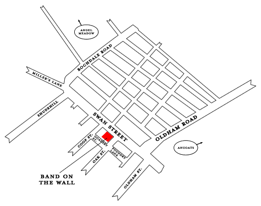
Illustrative map showing location of Band on the Wall
The block – on the eastern edge of the area that in the late 20th century was named the Northern Quarter – does not yet exist in the 1770s: the eastward drift from the town centre of piecemeal and speculative building in the 1750s and 1760s had not yet reached that side of town.1 A map of Manchester from c1772 shows that a few of the streets that comprise the present Northern Quarter have been laid out. This development was ‘not to an overall plan’, built as the need and opportunity grew, but at this time there is no building development close to the Band on the Wall block; the site was a field, possibly a ‘patchwork of gardens’, the description of the adjacent land that would become the site of the Smithfield Market.2
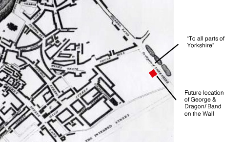
Figure 3 – Extract from ‘A Plan of Manchester and Salford’, T. Tinker, 1772 (Manchester Archives & Local Studies). Pin-pointed at the edge of a field is where the George & Dragon/Band on the Wall would be developed.
The path to Yorkshire
On the map we can see Shude Hill that has existed since the 16th Century and also a number of other streets, including High Street and Market Street but what eventually would become Swan Street, is only shown as an unnamed rough pathway, labelled on the map: ‘To all parts of YORKSHIRE’.
Due to the massive industrial development nearby, the area was now ‘attractive territory for housing the swelling numbers of mill workers and domestic weavers’3, and building construction would soon follow its inexorable eastward drift from the town centre. The path to ‘all parts of Yorkshire’ would shortly deserve a name of its own. Prior research (iCosse 2007) stated:
‘The Manchester and Salford Trade Directory for 1781 was the first to include the address of New Cross Street, the original name of Swan Street. The nascent nature of the community there is indicated by the fact that there were only four entries for the new thoroughfare, including one public house, the Boar’s-head:
Brown, James, carpenter & timberman, New cross
Holt, Robert, Bookbinder, New cross
Pickup, John, Boar’s-head, New cross
Shawcross, Edward, fustian manufacturer, New cross‘The lack of numbers for the addresses is another possible indication of how new the road was: the fact that at this time the Shudehill Pits [small reservoirs] were still in existence and so the northern side of the road was not inhabited may possibly have been a factor in this too.’
In fact it is likely that New Cross was just a generic term for the area, not the street, and the four addresses above were at the historic meeting place of New Cross, the junction of Oldham Street, Oldham Road, Great Ancoats Street and what would become Swan Street. For example, from 1776 the Boar’s Head is recorded at Oldham Road, with John Pickup the licensee from 1780-84. What is certain is that ‘the decades after 1780 witnessed a building boom in Manchester’4 and that it would not be long before the ‘Band on the Wall block’ emerged on New Cross Street. Indeed, by 1788, the site is no longer a field but has been built on, as is shown on the rough map included in Lewis’s Directory of this date.
So the early form of the Band on the Wall block is first recorded in 1788. This accords with title deed and Land Registry documents, in possession of Band on the Wall’s current owners, the charity Inner City Music, that record the conveyance in 1786 of land now occupied by Band on the Wall. The parties named in the documents are Josiah Birch, Thomas Coop and John Taylor.
Mr Birch
In 1781, Josiah Birch & Son were fustian*, silk & check manufacturers in High Street. Theirs was an established and expanding market and it would appear that Mr Birch might have invested in the undeveloped land nearby.
*fustian – coarse cloth of cotton/linen or cotton/wool mixture.
Mr Coop
Thomas Coop’s name was given to Coop Street, at the side of the current Smithfield Hotel. In the 1790s, he lived and traded as a loom maker at No 1 Coop Street5 – on part of the site of the existing Smithfield Hotel – and by 1806 had a shop and warehouse on Swan Street,6 probably on the site of the current Burton Arms.
Mr Taylor
John Taylor is the corn and flour dealer who in 1788 traded from premises in nearby Tib Street and by 17947 was living and working from Nos 10 & 11 Swan Street, part of the existing Band on the Wall site, subsequently renumbered. A significant local dealer, he may have been responsible for the development of the block on his land. He also had stables in Foundry Lane, no doubt providing the horse-power for the distribution by cart of his flour throughout the area. He may also have been the first licensee in 1799 of The Rising Sun,8 at the corner of Swan Street & Rochdale Road, a public-house that had a long and at times notorious history, including as a music hall. At this time, a Peter Taylor, perhaps a relative, is the publican of The Fleece, round the corner at 24 Oak Street.
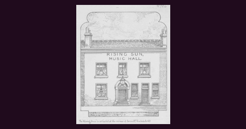
Figure 5 – The Rising Sun Music Hall, corner of Swan Street and Rochdale Road (Manchester Archives & Local Studies)
Further detail of the Band on the Wall block is provided by Green’s map of Manchester, 1787-94:
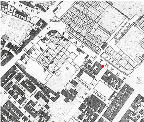
Figure 6 – Extract of Green’s Map of Manchester, 1787-94 (Manchester Archives & Local Studies)
On this map New Cross Street is now named Swan Street and what was Aubery Lane at the back of the block is now Foundery Lane, later spelt Foundry Lane, part of which subsequently became Goadsby Street, named after one of the councillors on the Markets Committee, Thomas Goadsby, who would go on to become Mayor of Manchester (1861-62).
Ironworks next door
The foundry, after which the lane was named in the early 1790s, was The Griffin Iron Foundry of John Smith & Co on Swan Street. This was almost certainly on the site at the corner with Oak Street, now opposite Band on the Wall, part of the larger site that has been developed by Workshop Properties Ltd and opened as 14 retail and office units in 2012. The foundry also was accessed from Foundry Lane where, appropriately, Mr Smith operated a smithy. In 1801 Mr Smith lived at 18 Oak Street; other members of the Smith family were involved in the business, the address of which originally was the Shudehill Pits in 1788. The ready supply of water from these small reservoirs on the north side of Swan Street no doubt was advantageous to the foundry that would have provided ironwork for the local and booming building industry, as well as for other local trades.
Courtyard and atrium
The site of the Band on the Wall block broadly follows the building outline illustrated in the 1788 map, but Green’s map also shows ‘the eastern half filled with buildings that are arranged around a courtyard, the form of which appears to have survived to the present day’. (iCosse 2007) A passage, perhaps wide enough to take horse and cart, or at least a hand-cart, is shown linking the courtyard to Foundery Lane. The courtyard subsequently became a kind of atrium and this feature was reinstated in 2009 in the form of the refurbished, pitched, glazed roof above The Picturehouse bar in the current Band on the Wall. The ancient passage through to Foundry Lane/Goadsby Street from The Picturehouse site also is retained today, if in an adapted form and with its own 999-year lease.
At the end of the 18th century, it would appear that the only parts of the block not built on are part of the site now occupied by the Smithfield Hotel and the Burton Arms.
1Simon Taylor & Julian Holder, ‘Manchester’s Northern Quarter’,p11, English Heritage 2008
2’The Shudehill & NQ Area of Manchester’, p22, English Heritage
3Simon Taylor & Julian Holder, ‘Manchester’s Northern Quarter’,p23, English Heritage 2008
4Ibid, Simon Taylor & Julian Holder,p20
5Scholes Directory of Manchester, 1794 & 1797
8Neil Richardson, unpublished notes on Manchester pubs, courtesy Susan Richardson